|
 BRITISH
COLUMBIA'S SUNSHINE COAST TOUR BRITISH
COLUMBIA'S SUNSHINE COAST TOUR
3 to 6 days
To
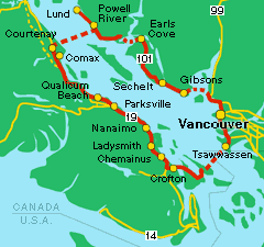
begin your tour of BC's Sunshine
Coast, take the ferry from Horseshoe
Bay to Langsdale Terminal.
Highway
101 takes you to Gibsons
Landing, 5 km/3 miles northwest of
the terminal. There you can dine on BC seafood, browse
the town's small shops and galleries or take in a
restful stroll along Gibson's waterfront.
Travelling
north on Highway 101, you will come to Roberts Creek
and nearby Cliff Giller Regional Park, with its rustic
log bridges and tranquil forest trails. Roberts Creek
Provincial Park nearby, is a popular campground with
access to local beaches.
Sechelt
(21 km/13 miles from Gibsons) is the home of the
House of Hewhiwus (House of Chiefs), a cultural centre
that houses a gallery, theatre and museum, as well
as the band offices for the Sechelt Nation. Sechelt
is also well known for its Festival of the Written
Arts. Camp in Porpoise Bay Provincial Park, or enjoy
one of the coast's many bed and breakfast accommodations.
Halfmoon
Bay is just north of Sechelt, a scenic cove that is
popular among boaters. Smuggler's Cove Provincial
Marine Park offers scenic marine trails for day use.
Just north of Halfmoon Bay is Pender Harbour, home
of some of the best
sports fishing
on the coast.
 |
|
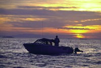
Fishing
the Coast off Powell River
Photo Courtesy of Sean Percy
|
Heading
north on Highway 101, you come to Earls Cove, the
ferry connector to Saltery Bay and Powell River. Powell
River is 31 km/19 miles from Saltery
Bay. Check out Powell River's great diving sites or
simply sit back and enjoy the best sunsets British
Columbia's Sunshine Coast has to offer.
24
km/14 miles north of Powell River is Lund, a tiny
hamlet on the edge of a land spit. There are any number
of excursions to take in the Powell River/Lund area,
accessible either by chartered motor boat, kayak,
canoe or back road. BC Forest Service Recreation Sites
dot the Powell Forest all around the area. RV parks
are situated closer to town.
 |
|
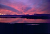
Sunsets
are Spectacular at Powell River
Photo: Powell River Chamber of Commerce
|
Your
drive now turns southwest, as you board the ferry
for
Courtenay,
on Vancouver
Island. Once on the Island, your main
highway will be Highway 19 south and will take you
through the towns and historic sites of Comox,
Qualicum Beach,
Parksville
and Nanaimo.
Filberg
Lodge and Park in Comox (6 km/4 miles east of Courtenay),
is a 1930's heritage estate and home of the famous
Filberg Festival. Further south, anglers will enjoy
Parksville (72 km/45 miles from Comox), renown for
both its fresh and saltwater fishing.
 |
|
Walking
the West Coast Trail
Photo Courtesy of Carolyn Dunnington
|
Englishman
River Falls Provincial Park is just off Highway 4,
your connector to the Central
West Coast of Vancouver Island, and
some of BC's most unique parks. At the end of Highway
4 lies the hamlets of Tofino
and Ucluelet.
In Ucluelet (116 km/73 miles east of Parksville),
you can charter a boat that will take you to the Broken
Group Islands, south of Highway 4.
Tofino, (42 km/26 miles north of Ucluelet) hosts the
Pacific Rim Whale festival in the Spring, a great
way to learn about West Vancouver Island's ecology
and culture.
Some
of the small coastal and inland towns just off of
Highway 4 are accessible by gravel roads from Port
Alberni (50 km/31 miles from Parksville).
The town of Bamfield
can be reached by a two-day mini cruise from Port
Alberni as well as by back road.
 |
|
Victoria's
Old World Charm
Photo Courtesy of Tourism BC
|
Returning
to Highway 19 south, you arrive at Nanaimo,
the third oldest city in BC. Scuba
dive off Nanaimo's coast, or check
out the self-guided walking tour of some of the city's
350 heritage buildings.
To
conclude your tour, head to Victoria
for some old world hospitality (113 km/70 miles from
Nanaimo). Stay in one of the many historic bed and
breakfast accommodations located in the city.
Return
to Vancouver
via ferry at Swartz Bay.
Be
sure to browse the Sunshine Coast
Points of Interest
Read
a Travelog:
Check
BC
Ferries Information
|

 BRITISH
COLUMBIA'S SUNSHINE COAST TOUR


